|
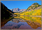
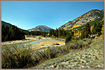
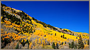
Maroon Bells, Aspen, Colorado ~ Day 1
Maroon Bells is a very special place, located ten miles West of Aspen. The peaks known as the Maroons rise in the background when you stand on the bank of Maroon Lake, offering a lush image which changes constantly for the next several hours.
To capture the phenomenon, one should arrive at 5:30 A.M. during the latter portion of September when the aspen leaves are turning yellow all over western Colorado. Parenthetically, that means freezing to death for a couple of hours while one awaits the alpenglow to paint the Maroons at sunrise. Then, in a very gradual way, the Sun invades the valley and illuminates everything.

|
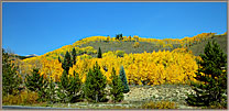
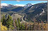
Independence Pass and the Lake District
After a visit to the magic of Maroon Bells near Aspen, Route 82 between Aspen and Leadville passes through some magnificent mountain scenery and reaches a height of more than 12,000 feet at Independence Pass. This pass is where the road crosses the Continental Divide.
As you then drive eastward, you swoop down into the Lakes District, where one finds more hillsides carpeted with aspens changing color and meandering streams.
|
|
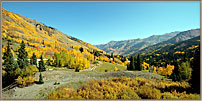
Kebler Pass, Colorado
As you drive South from Grand Junction toward Montrose and the Black Canyon of the Gunnison, there is a side road from near Delta which leads to Crested Butte. While the greenery would be attractive at any time of year, the color of the aspens in late September paints all the hillsides. With rich color, making them a dream for photographers.
|
| |
Ouray ~ The Million Dollar Highway
The town of Montrose, Colorado is close to the magnificent Black Canyon of the Gunnison. It lies along Route 550, which runs South from Grand Junction all the way to New Mexico.
The colorful history of this road is detailed here
The particular section from Ouray to Silverton is known as The Million-Dollar Highway’ for reasons that are not completely clear. Any of the stories for the name are fun to tell—and one can’t be proven wrong… |
| |
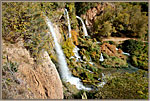
Rifle Falls
Rifle Falls lies just North of Rifle, Colorado, a few miles North of Route 70. That is the main highway running East/West across both Utah and Colorado.
Rifle Falls is a small but well-tended state park with a triple waterfall, offering a refreshing pause as one crosses these southwestern states. |
| |
Ophir Pass
Ophir Pass is one of several ways to make one’s way through the high peaks near Telluride and Ouray. Ophir Pass has a particularly exquisite setting, as you will see in this gallery. Most visitors have no idea this gem is there as they drive the highway, but it should be on everyone’s list of places to experience.
|
| |
Rocky Mountain National Park
The two most-traveled roads are Trail Ridge Road, which leads from entry gates near the town of Estes Park up to the Alpine visitor’s Center, and the road to Bear Lake. On Trail Ridge Road, we find some good-sized parking areas at overlook such as Many Parks Curve, Rainbow Curve, Split Rock, Forest Canyon and the Gore Range Overview. There are also small pull-outs with some dramatic views along the road.
These overlooks offer views down into broad meadows and winding streams, including Sheep Meadow, Horseshoe Park and Moraine Park. In the morning, Elk and Moose are common in the meadows, and drivers may encounter them in the darkness right on the roads.
|
| |
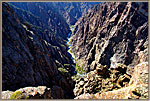
Black Canyon
The Black Canyon of the Gunnison is in a National Park in southwestern Colorado. What is unusual is the narrowness and depth of the canyon, and the black volcanic rock through which the Gunnison River has eroded. It has high overlooks above sheer walls 2,000 feet high, and a scenic drive down to the river. All of these scenic attractions make for an enjoyable couple of days—especially when the Fall colors are everywhere.
|
| |
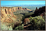
Colorado National Monument
Colorado National Monument is a high plateau located near Grand Junction on Interstate 70 crossing central Colorado toward Denver. The northern side of the raised plateau has had enormous canyons eroded into it by ancient rains. The park service built a winding road to follow the zig-zag rim above these canyons, providing a wealth of easy-to-use scenic overlooks.
|
| |
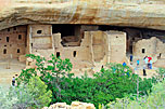
Mesa Verde National Park
Mesa Verde is a good-sized park, but access to its prime attractions is from two long ridge-like mesa. Those attractions are the sites of several hundred Anasazi settlements from a thousand years ago.
While some Anasazi homes were pit houses (holes in the ground with a roof), many were sophisticated structures of stone blocks in crevices in sheer cliffs. Many of these cliff homes are three hundred feet above their valley floors. Imagine bringing firewood, food and water up or down the cliffs to your home!
|
Carl Roessler
P.O. Box 33668
Las Vegas, NV 89133
voice: 702.562.0226
All material in this Web Site is Copyright © Carl Roessler
2025 - All rights reserved.
Maintenance by Patricia
of Visual Ad Worx
Modified 03.29.25